Welcome to Oakwood – a unique experience in suburban living.
We invite you to drive through our community and enjoy some of its most beautiful homes and parks. You
may want to have a passenger to read the directions and background information. Please keep a watch for
joggers, bikers, and walkers. Oakwood residents use our streets
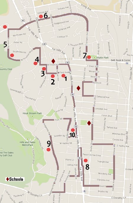
1. The City Building
Start at the Oakwood City Hall at 30 Park Ave, off Far Hills Ave. Its Tudor style sets the tone for the whole
community and dates back to the 1920s, with several additions incorporated over the years. Oakwood is one of
very few place which run a combined police, fire, and emergency services department. Created in 1924, Oakwood's
Public Safety Department is the second oldest continuing consolidated department in the country.
2. Hawthorn Hill
Travel west to Harman Ave away from Far Hills Ave. Continue through the intersection on Park Ave. The large Southern colonial
house to your left is Hawthorn Hill. Orville Wright, his sister Katherine, and their father Milton lived in this home. Wilbur
Wright helped plan the house, but contracted typhoid fever and died before the home’s completion in 1914. They named the
property “Hawthorn Hill” because they had lived on Hawthorn Street in Dayton when they were young boys. Orville Wright lived
here from 1914 until his death in 1948. The symmetrical house has two-pillared facades, on the south and north sides, which
are connected by a wide and elegant reception hall. Built in a time before air conditioning, the home's design maximized the
flow of fresh air throughout the house. From 1949 to August 2006, the home was a corporate guesthouse for the National Cash Register (NCR)
Company. Currently (2020), the home is managed by Dayton History and listed on the National Register of Historic Places.
3. Smith Gardens
Continue on Park Ave, turn right on Oakwood Ave, and continue to Walnut Ln on your left, where you will find Smith Gardens. This
is beautiful, quiet place that you may want to return to if you can’t stop for a stroll today. The garden was planted in the 1930s
by property owners, Carlton and Jeanette Smith, with the intent of having continuous bloom. It is now an Oakwood city park, and
the city’s horticulturist coordinates its upkeep. In April 1996, Ohio Magazine called Smith Gardens the “finest tiny public garden
in Ohio. It's like a secret treasure on an ordinary side street.” Residents use Smith Gardens for family picnics and as a backdrop
for family photographs. The City of Oakwood hosts summer blanket concert series in the park.
4. Runnymede Playhouse
Continue on Oakwood Ave for one more block. Turn left on W. Dixon Ave. Go one block to Runnymede Rd.
Straight ahead of you at the stop sign is the former site of the Runnymede Playhouse. Today, homes built
in the 1970s cover the secret the playhouse once held. Originally part of the Talbott family estate, the Runnymede
Playhouse was first a social and entertainment center for the Oakwood community. Groups would gather to play games, sports,
and hold social meetings in the massive building. The playhouse was large enough for 1200 women to play bridge together.
The complex included indoor tennis and squash courts, as well as a ballroom and stage.
During WWII, the US Army used the playhouse for research and production of polonium triggers for the atomic bomb. The Monsanto
Chemical Company ran five total research sites around Dayton. The Runnymede Playhouse, known as Unit IV, housed much of the
scientific research relevant to what was known as the Dayton Project prior to the completion of the better-known Mound lab in
Miamisburg. Although the playhouse’s Oakwood neighbors had no idea of the activities going on at the site, nearly 90 people
worked at Unit IV.
From the Dayton Daily News: "Between big trucks rolling in and out, the floodlights and heavy-duty power lines strung all over,
the place was a real mess," Lee Jones of Oakwood recalled in a 1983 story about Runnymede Playhouse, "But those were the days
when you knew enough not to ask questions."
In 1949, operations moved to Miamisburg, and the following year, the Runnymede Playhouse was dismantled and later buried in Tennessee.
Turn right onto Runnymede Rd and continue to Thruston Blvd. as you enter the country club area. Turn left onto Thruston Blvd and continue
on this road. Its name will change to Kramer Rd as it curves to the right.
5. Kramer Road and Sugar Camp
Kramer Rd was the original home to William Kramer’s Winery and Pleasure Gardens in the 1880s. City of Dayton residents would ride on
horse and in carriage to the vineyard to spend a relaxing day and enjoy the impressive flower and shrub gardens on the property. In
this area, you will find some of the oldest homes in Oakwood. You will also pass the Dayton Country Club on your left. While located
in the City of Kettering, the DCC has served Oakwood’s recreational and social needs since its inception in 1898.
Kramer Rd will dead end into Schantz Ave. Across the road, you will see Sugar Camp. Originally part of Colonel Robert Patterson’s property
and site of a grove of sugar maples, Sugar Camp became a corporate training facility for the National Cash Register Company (NCR) in
the early 1900s. It was transferred out of NCR control and now houses a small office park on top of the hill.
6. Schantz Historical District
Go right on Schantz Ave, continuing to Far Hills Ave with the gazebo on your right identifying the entrance to Oakwood from downtown.
Continue through the intersection to the second traffic light at Oakwood Ave. Jogging right, continue on Schantz Ave, passing the
massive stone entrance gateway. Along this road, you will find a variety of homes in Oakwood’s typical mixed architecture, a result of
early development with houses spaced apart, and the subsequent pressure to sell lots in between in the 1960s. This is the Schantz
Historical District, Oakwood’s only neighborhood on the National Registry of Historic Places. For more information on the homes in
this neighborhood, see the Oakwood Historical Society’s guided tour available on the website.
7. Community Center, Schools, & Parks
Schantz Ave meanders to the south and up a hill where it levels off to homes typical of the 1920s and 1930s. There is a light at the
intersection of Patterson Rd. To the left is the Oakwood Community Center, a hub of recreational and educational activity since the 1920s.
Behind the center are the community swimming pool and tennis courts.
Turn left at Patterson Rd and proceed one block. On your left you will see Shafor Park, a playground and the gathering place for the annual
community Ice Cream Social. At the corner of Patterson and Shafor you will see the Michael Bashaw sculpture, “Wings/Lift Compounded (Defy
the Impossible),” installed in 2003, celebrating the Centennial of Flight.
Turn right onto Shafor Blvd, and proceed four blocks to Spirea Dr and turn right. Travel one block to Schantz Ave and turn left. As you
continue south, the junior high and the high school are on your right and the Mack Hummon Field on your left. At Dellwood Ave, turn
left and proceed one block passing the baseball field.
At Shafor Blvd, turn right and drive south to the first traffic light. After the light, you will pass the Edwin D. Smith Elementary
School, one of two elementary schools in Oakwood.
At Hadley Ave, turn left at the church and proceed two blocks to Delaine Ave. Turn right and continue to Orchard Dr, where you will
see one of several popular parks with playground facilities, a picnic shelter, wading pool, and tennis and basketball courts. Continue
south to East Dr, where you will turn right and continue for three blocks which will bring you to Far Hills Ave.
8. Far Hills Shopping District
Turn right just before Far Hills Ave onto the access road to cruise the shopping district. On your right is Dorothy Lane Market, a
family-owned independent grocery store serving the Oakwood community since 1948. Over the next several blocks there are many goods and
services for Oakwood and surrounding area residents.
At Peach Orchard Ave, proceed through the light straight onto Far Hills Ave
and get in the left lane. Turn around at the first division in the boulevard and head south again. At the light, enter the access road on
your right to cruise the stores on the west side of Far Hills Ave. Many of these shops were originally built as homes. Look at the
side and rear of these buildings and you will see the original home architecture.
Turn right onto Dell Park Ave and proceed to Roanoke Ave. Turn left, go one block, and turn right onto Oak Knoll Dr. Take Oak Knoll Dr
two blocks to Ridgeway Rd.
9. Ridgeway Road
Turn right onto Ridgeway Rd. You will pass several estates built in the 1920s and 1930s for Dayton’s and Oakwood’s business and community leaders.
This roadway was originally laid out and designed by Frederick Olmstead (of Central Park fame) for his friend and constant client, John H. Patterson,
President of the National Cash Register Company.
Proceed to Park Rd, turn right, and continue to Coolidge Dr, and turn right. On your left will be the rear of the Brookdale Oakwood senior
assisted living facility. Proceed on Coolidge Dr, the original site of sand and gravel quarries that provided materials for roads and homes
throughout Oakwood through the 1930s. Proceed to Grandon Rd and turn left. Go one block to Far Hills Ave.
Turn left on Far Hills Ave.
10. The Long-Romspert House Museum
The Oakwood Historical Society’s Long-Romspert House Museum will be on your left across the boulevard. The yellow home
with the sign in the front yard is on the National Register of Historic Places. It is one of the oldest homes in Oakwood (started in 1863)
and was inhabited by one family the entire time until it was given to the Oakwood Historical Society in 1985.
Ahead on your right will be the Wright Memorial Public Library. It serves the community needs with a variety of programming, services, and
materials. As you proceed north, try to imagine electric streetcars running up and down Far Hills Ave in the center median. The Oakwood
Street Railway Company operated streetcars until 1936, when the streetcars were replaced by electric trolley buses and the rails were removed.
Ahead on your right is Oakwood High School. The high school also serves as a community meeting place with a large auditorium.
There is a traffic light at Park Ave. Get in the left lane and at the next block (Dixon Ave) turn left. Proceed on Dixon Ave
past a large church to the corner of Harman Ave. Across the street on the right is Harman Elementary School, the other elementary school
in Oakwood on this tour. Turn left on Harman Ave and go one block to Park Ave. Turn left and you have returned to City Hall. Along Park
Ave you will see the second shopping district in Oakwood. Please note The Little Exchange in the green house on your left. Started by the
Junior League of Dayton in 1931, a group of dedicated volunteer women assumed responsibility for it in 1956. The independent volunteer-run
store today gives 100% of its proceeds to the Children’s Medical Center in Dayton.